Downloading with PC
[1]:
# install with
# !pip install terragon-downloader[pc]
[1]:
import terragon
import geopandas as gpd
import xarray as xr
from utils import visualize_sat_images, list_of_dicts_to_tree
[3]:
# we will use the sample data to download a minicube
# other datasets can be found here: https://planetarycomputer.microsoft.com/catalog
gdf = gpd.read_file("data/TUM_OTN.geojson")
gdf = gdf.to_crs("EPSG:32632")
arguments = dict(
    shp=gdf,
    collection="sentinel-2-l2a",
    start_date="2021-01-01",
    end_date="2021-01-05",
    bands=["B02", "B03", "B04"],
    resolution=10,
    download_folder="tests/download/",
)
gdf.crs
[3]:
<Projected CRS: EPSG:32632>
Name: WGS 84 / UTM zone 32N
Axis Info [cartesian]:
- E[east]: Easting (metre)
- N[north]: Northing (metre)
Area of Use:
- name: Between 6°E and 12°E, northern hemisphere between equator and 84°N, onshore and offshore. Algeria. Austria. Cameroon. Denmark. Equatorial Guinea. France. Gabon. Germany. Italy. Libya. Liechtenstein. Monaco. Netherlands. Niger. Nigeria. Norway. Sao Tome and Principe. Svalbard. Sweden. Switzerland. Tunisia. Vatican City State.
- bounds: (6.0, 0.0, 12.0, 84.0)
Coordinate Operation:
- name: UTM zone 32N
- method: Transverse Mercator
Datum: World Geodetic System 1984 ensemble
- Ellipsoid: WGS 84
- Prime Meridian: Greenwich
[2]:
tg = terragon.init("pc")  # credentials are not needed for public datasets
# tg = terragon.init("pc", credentials={"api_key": "<your_api_key>"})
Finding collections
[3]:
# explore the PC data on their website: https://planetarycomputer.microsoft.com/catalog
collections = tg.retrieve_collections(
    query={"id": "Sentinel.1.*"}, fields=["id", "title"]
)  # filter field with regex and only return wished fields
list_of_dicts_to_tree(collections)
[3]:
download
[5]:
# planetary computer is accessed via the stac catalog
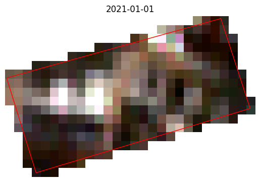
ds = tg.create(**arguments)
# or
# items = tg.search(**arguments)
# ds = tg.download(items)
ds
[5]:
<xarray.Dataset> Size: 12kB
Dimensions:      (y: 18, x: 28, time: 2)
Coordinates:
  * y            (y) float64 144B 5.326e+06 5.326e+06 ... 5.326e+06 5.326e+06
  * x            (x) float64 224B 6.976e+05 6.976e+05 ... 6.979e+05 6.979e+05
  * time         (time) datetime64[ns] 16B 2021-01-01T10:23:29.024000 2021-01...
    spatial_ref  int64 8B 0
Data variables:
    B02          (time, y, x) float32 4kB nan nan nan 798.0 ... nan nan nan
    B03          (time, y, x) float32 4kB nan nan nan 779.0 ... nan nan nan
    B04          (time, y, x) float32 4kB nan nan nan 857.0 ... nan nan nan
Attributes:
    crs:          EPSG:32632
    data_source:  PC
collection: sentinel-2-l2a[6]:
visualize_sat_images(ds, gdf, list(reversed(arguments["bands"])))
[7]:
# the ouptut of the search is a collection of items
tg.search(**arguments)
[7]:
- type "FeatureCollection"
features[] 2 items
0
- type "Feature"
- stac_version "1.0.0"
stac_extensions[] 3 items
- 0 "https://stac-extensions.github.io/eo/v1.0.0/schema.json"
- 1 "https://stac-extensions.github.io/sat/v1.0.0/schema.json"
- 2 "https://stac-extensions.github.io/projection/v1.0.0/schema.json"
- id "S2A_MSIL2A_20210103T101411_R022_T32UPU_20210103T230314"
geometry
- type "Polygon"
coordinates[] 1 items
0[] 12 items
0[] 2 items
- 0 10.58654386
- 1 47.75286689
1[] 2 items
- 0 10.59342777
- 1 47.77197094
2[] 2 items
- 0 10.6469027
- 1 47.91831925
3[] 2 items
- 0 10.70038222
- 1 48.06470124
4[] 2 items
- 0 10.75451719
- 1 48.21107556
5[] 2 items
- 0 10.80923715
- 1 48.35740379
6[] 2 items
- 0 10.86418909
- 1 48.50378025
7[] 2 items
- 0 10.91940419
- 1 48.65009404
8[] 2 items
- 0 10.95140246
- 1 48.73417335
9[] 2 items
- 0 11.85243871
- 1 48.71769475
10[] 2 items
- 0 11.79809472
- 1 47.73104448
11[] 2 items
- 0 10.58654386
- 1 47.75286689
bbox[] 4 items
- 0 10.58654386338165
- 1 47.73104447774509
- 2 11.852438708473068
- 3 48.734173354019894
properties
- datetime "2021-01-03T10:14:11.024000Z"
- platform "Sentinel-2A"
- proj:epsg 32632
instruments[] 1 items
- 0 "msi"
- s2:mgrs_tile "32UPU"
- constellation "Sentinel 2"
- s2:granule_id "S2A_OPER_MSI_L2A_TL_ESRI_20210103T230316_A028905_T32UPU_N02.12"
- eo:cloud_cover 97.155553
- s2:datatake_id "GS2A_20210103T101411_028905_N02.12"
- s2:product_uri "S2A_MSIL2A_20210103T101411_N0212_R022_T32UPU_20210103T230314.SAFE"
- s2:datastrip_id "S2A_OPER_MSI_L2A_DS_ESRI_20210103T230316_S20210103T101417_N02.12"
- s2:product_type "S2MSI2A"
- sat:orbit_state "descending"
- s2:datatake_type "INS-NOBS"
- s2:generation_time "2021-01-03T23:03:14.975Z"
- sat:relative_orbit 22
- s2:water_percentage 0.016916
- s2:mean_solar_zenith 72.3966057727788
- s2:mean_solar_azimuth 164.847334475601
- s2:processing_baseline "02.12"
- s2:snow_ice_percentage 0.631809
- s2:vegetation_percentage 0.0
- s2:thin_cirrus_percentage 0.087814
- s2:cloud_shadow_percentage 0.0
- s2:nodata_pixel_percentage 28.428489
- s2:unclassified_percentage 0.000287
- s2:dark_features_percentage 2.190159
- s2:not_vegetated_percentage 0.005285
- s2:degraded_msi_data_percentage 0.0
- s2:high_proba_clouds_percentage 95.741832
- s2:reflectance_conversion_factor 1.03425585365498
- s2:medium_proba_clouds_percentage 1.325907
- s2:saturated_defective_pixel_percentage 0.0
links[] 6 items
0
- rel "collection"
- href "https://planetarycomputer.microsoft.com/api/stac/v1/collections/sentinel-2-l2a"
- type "application/json"
1
- rel "parent"
- href "https://planetarycomputer.microsoft.com/api/stac/v1/collections/sentinel-2-l2a"
- type "application/json"
2
- rel "root"
- href "https://planetarycomputer.microsoft.com/api/stac/v1/"
- type "application/json"
- title "Microsoft Planetary Computer STAC API"
3
- rel "self"
- href "https://planetarycomputer.microsoft.com/api/stac/v1/collections/sentinel-2-l2a/items/S2A_MSIL2A_20210103T101411_R022_T32UPU_20210103T230314"
- type "application/geo+json"
4
- rel "license"
- href "https://sentinel.esa.int/documents/247904/690755/Sentinel_Data_Legal_Notice"
5
- rel "preview"
- href "https://planetarycomputer.microsoft.com/api/data/v1/item/map?collection=sentinel-2-l2a&item=S2A_MSIL2A_20210103T101411_R022_T32UPU_20210103T230314"
- type "text/html"
- title "Map of item"
assets
AOT
- href "https://sentinel2l2a01.blob.core.windows.net/sentinel2-l2/32/U/PU/2021/01/03/S2A_MSIL2A_20210103T101411_N0212_R022_T32UPU_20210103T230314.SAFE/GRANULE/L2A_T32UPU_A028905_20210103T101417/IMG_DATA/R10m/T32UPU_20210103T101411_AOT_10m.tif?st=2025-01-19T11%3A31%3A19Z&se=2025-01-20T12%3A16%3A19Z&sp=rl&sv=2024-05-04&sr=c&skoid=9c8ff44a-6a2c-4dfb-b298-1c9212f64d9a&sktid=72f988bf-86f1-41af-91ab-2d7cd011db47&skt=2025-01-20T08%3A06%3A25Z&ske=2025-01-27T08%3A06%3A25Z&sks=b&skv=2024-05-04&sig=Lh230TWhOMMj2rv4zuxz9%2BYpZJr9S8H/8X500tnYnG4%3D"
- type "image/tiff; application=geotiff; profile=cloud-optimized"
- title "Aerosol optical thickness (AOT)"
proj:bbox[] 4 items
- 0 600000.0
- 1 5290200.0
- 2 709800.0
- 3 5400000.0
proj:shape[] 2 items
- 0 10980
- 1 10980
proj:transform[] 6 items
- 0 10.0
- 1 0.0
- 2 600000.0
- 3 0.0
- 4 -10.0
- 5 5400000.0
- gsd 10.0
roles[] 1 items
- 0 "data"
B01
- href "https://sentinel2l2a01.blob.core.windows.net/sentinel2-l2/32/U/PU/2021/01/03/S2A_MSIL2A_20210103T101411_N0212_R022_T32UPU_20210103T230314.SAFE/GRANULE/L2A_T32UPU_A028905_20210103T101417/IMG_DATA/R60m/T32UPU_20210103T101411_B01_60m.tif?st=2025-01-19T11%3A31%3A19Z&se=2025-01-20T12%3A16%3A19Z&sp=rl&sv=2024-05-04&sr=c&skoid=9c8ff44a-6a2c-4dfb-b298-1c9212f64d9a&sktid=72f988bf-86f1-41af-91ab-2d7cd011db47&skt=2025-01-20T08%3A06%3A25Z&ske=2025-01-27T08%3A06%3A25Z&sks=b&skv=2024-05-04&sig=Lh230TWhOMMj2rv4zuxz9%2BYpZJr9S8H/8X500tnYnG4%3D"
- type "image/tiff; application=geotiff; profile=cloud-optimized"
- title "Band 1 - Coastal aerosol - 60m"
proj:bbox[] 4 items
- 0 600000.0
- 1 5290200.0
- 2 709800.0
- 3 5400000.0
proj:shape[] 2 items
- 0 1830
- 1 1830
proj:transform[] 6 items
- 0 60.0
- 1 0.0
- 2 600000.0
- 3 0.0
- 4 -60.0
- 5 5400000.0
- gsd 60.0
eo:bands[] 1 items
0
- name "B01"
- common_name "coastal"
- description "Band 1 - Coastal aerosol"
- center_wavelength 0.443
- full_width_half_max 0.027
roles[] 1 items
- 0 "data"
B02
- href "https://sentinel2l2a01.blob.core.windows.net/sentinel2-l2/32/U/PU/2021/01/03/S2A_MSIL2A_20210103T101411_N0212_R022_T32UPU_20210103T230314.SAFE/GRANULE/L2A_T32UPU_A028905_20210103T101417/IMG_DATA/R10m/T32UPU_20210103T101411_B02_10m.tif?st=2025-01-19T11%3A31%3A19Z&se=2025-01-20T12%3A16%3A19Z&sp=rl&sv=2024-05-04&sr=c&skoid=9c8ff44a-6a2c-4dfb-b298-1c9212f64d9a&sktid=72f988bf-86f1-41af-91ab-2d7cd011db47&skt=2025-01-20T08%3A06%3A25Z&ske=2025-01-27T08%3A06%3A25Z&sks=b&skv=2024-05-04&sig=Lh230TWhOMMj2rv4zuxz9%2BYpZJr9S8H/8X500tnYnG4%3D"
- type "image/tiff; application=geotiff; profile=cloud-optimized"
- title "Band 2 - Blue - 10m"
proj:bbox[] 4 items
- 0 600000.0
- 1 5290200.0
- 2 709800.0
- 3 5400000.0
proj:shape[] 2 items
- 0 10980
- 1 10980
proj:transform[] 6 items
- 0 10.0
- 1 0.0
- 2 600000.0
- 3 0.0
- 4 -10.0
- 5 5400000.0
- gsd 10.0
eo:bands[] 1 items
0
- name "B02"
- common_name "blue"
- description "Band 2 - Blue"
- center_wavelength 0.49
- full_width_half_max 0.098
roles[] 1 items
- 0 "data"
B03
- href "https://sentinel2l2a01.blob.core.windows.net/sentinel2-l2/32/U/PU/2021/01/03/S2A_MSIL2A_20210103T101411_N0212_R022_T32UPU_20210103T230314.SAFE/GRANULE/L2A_T32UPU_A028905_20210103T101417/IMG_DATA/R10m/T32UPU_20210103T101411_B03_10m.tif?st=2025-01-19T11%3A31%3A19Z&se=2025-01-20T12%3A16%3A19Z&sp=rl&sv=2024-05-04&sr=c&skoid=9c8ff44a-6a2c-4dfb-b298-1c9212f64d9a&sktid=72f988bf-86f1-41af-91ab-2d7cd011db47&skt=2025-01-20T08%3A06%3A25Z&ske=2025-01-27T08%3A06%3A25Z&sks=b&skv=2024-05-04&sig=Lh230TWhOMMj2rv4zuxz9%2BYpZJr9S8H/8X500tnYnG4%3D"
- type "image/tiff; application=geotiff; profile=cloud-optimized"
- title "Band 3 - Green - 10m"
proj:bbox[] 4 items
- 0 600000.0
- 1 5290200.0
- 2 709800.0
- 3 5400000.0
proj:shape[] 2 items
- 0 10980
- 1 10980
proj:transform[] 6 items
- 0 10.0
- 1 0.0
- 2 600000.0
- 3 0.0
- 4 -10.0
- 5 5400000.0
- gsd 10.0
eo:bands[] 1 items
0
- name "B03"
- common_name "green"
- description "Band 3 - Green"
- center_wavelength 0.56
- full_width_half_max 0.045
roles[] 1 items
- 0 "data"
B04
- href "https://sentinel2l2a01.blob.core.windows.net/sentinel2-l2/32/U/PU/2021/01/03/S2A_MSIL2A_20210103T101411_N0212_R022_T32UPU_20210103T230314.SAFE/GRANULE/L2A_T32UPU_A028905_20210103T101417/IMG_DATA/R10m/T32UPU_20210103T101411_B04_10m.tif?st=2025-01-19T11%3A31%3A19Z&se=2025-01-20T12%3A16%3A19Z&sp=rl&sv=2024-05-04&sr=c&skoid=9c8ff44a-6a2c-4dfb-b298-1c9212f64d9a&sktid=72f988bf-86f1-41af-91ab-2d7cd011db47&skt=2025-01-20T08%3A06%3A25Z&ske=2025-01-27T08%3A06%3A25Z&sks=b&skv=2024-05-04&sig=Lh230TWhOMMj2rv4zuxz9%2BYpZJr9S8H/8X500tnYnG4%3D"
- type "image/tiff; application=geotiff; profile=cloud-optimized"
- title "Band 4 - Red - 10m"
proj:bbox[] 4 items
- 0 600000.0
- 1 5290200.0
- 2 709800.0
- 3 5400000.0
proj:shape[] 2 items
- 0 10980
- 1 10980
proj:transform[] 6 items
- 0 10.0
- 1 0.0
- 2 600000.0
- 3 0.0
- 4 -10.0
- 5 5400000.0
- gsd 10.0
eo:bands[] 1 items
0
- name "B04"
- common_name "red"
- description "Band 4 - Red"
- center_wavelength 0.665
- full_width_half_max 0.038
roles[] 1 items
- 0 "data"
B05
- href "https://sentinel2l2a01.blob.core.windows.net/sentinel2-l2/32/U/PU/2021/01/03/S2A_MSIL2A_20210103T101411_N0212_R022_T32UPU_20210103T230314.SAFE/GRANULE/L2A_T32UPU_A028905_20210103T101417/IMG_DATA/R20m/T32UPU_20210103T101411_B05_20m.tif?st=2025-01-19T11%3A31%3A19Z&se=2025-01-20T12%3A16%3A19Z&sp=rl&sv=2024-05-04&sr=c&skoid=9c8ff44a-6a2c-4dfb-b298-1c9212f64d9a&sktid=72f988bf-86f1-41af-91ab-2d7cd011db47&skt=2025-01-20T08%3A06%3A25Z&ske=2025-01-27T08%3A06%3A25Z&sks=b&skv=2024-05-04&sig=Lh230TWhOMMj2rv4zuxz9%2BYpZJr9S8H/8X500tnYnG4%3D"
- type "image/tiff; application=geotiff; profile=cloud-optimized"
- title "Band 5 - Vegetation red edge 1 - 20m"
proj:bbox[] 4 items
- 0 600000.0
- 1 5290200.0
- 2 709800.0
- 3 5400000.0
proj:shape[] 2 items
- 0 5490
- 1 5490
proj:transform[] 6 items
- 0 20.0
- 1 0.0
- 2 600000.0
- 3 0.0
- 4 -20.0
- 5 5400000.0
- gsd 20.0
eo:bands[] 1 items
0
- name "B05"
- common_name "rededge"
- description "Band 5 - Vegetation red edge 1"
- center_wavelength 0.704
- full_width_half_max 0.019
roles[] 1 items
- 0 "data"
B06
- href "https://sentinel2l2a01.blob.core.windows.net/sentinel2-l2/32/U/PU/2021/01/03/S2A_MSIL2A_20210103T101411_N0212_R022_T32UPU_20210103T230314.SAFE/GRANULE/L2A_T32UPU_A028905_20210103T101417/IMG_DATA/R20m/T32UPU_20210103T101411_B06_20m.tif?st=2025-01-19T11%3A31%3A19Z&se=2025-01-20T12%3A16%3A19Z&sp=rl&sv=2024-05-04&sr=c&skoid=9c8ff44a-6a2c-4dfb-b298-1c9212f64d9a&sktid=72f988bf-86f1-41af-91ab-2d7cd011db47&skt=2025-01-20T08%3A06%3A25Z&ske=2025-01-27T08%3A06%3A25Z&sks=b&skv=2024-05-04&sig=Lh230TWhOMMj2rv4zuxz9%2BYpZJr9S8H/8X500tnYnG4%3D"
- type "image/tiff; application=geotiff; profile=cloud-optimized"
- title "Band 6 - Vegetation red edge 2 - 20m"
proj:bbox[] 4 items
- 0 600000.0
- 1 5290200.0
- 2 709800.0
- 3 5400000.0
proj:shape[] 2 items
- 0 5490
- 1 5490
proj:transform[] 6 items
- 0 20.0
- 1 0.0
- 2 600000.0
- 3 0.0
- 4 -20.0
- 5 5400000.0
- gsd 20.0
eo:bands[] 1 items
0
- name "B06"
- common_name "rededge"
- description "Band 6 - Vegetation red edge 2"
- center_wavelength 0.74
- full_width_half_max 0.018
roles[] 1 items
- 0 "data"
B07
- href "https://sentinel2l2a01.blob.core.windows.net/sentinel2-l2/32/U/PU/2021/01/03/S2A_MSIL2A_20210103T101411_N0212_R022_T32UPU_20210103T230314.SAFE/GRANULE/L2A_T32UPU_A028905_20210103T101417/IMG_DATA/R20m/T32UPU_20210103T101411_B07_20m.tif?st=2025-01-19T11%3A31%3A19Z&se=2025-01-20T12%3A16%3A19Z&sp=rl&sv=2024-05-04&sr=c&skoid=9c8ff44a-6a2c-4dfb-b298-1c9212f64d9a&sktid=72f988bf-86f1-41af-91ab-2d7cd011db47&skt=2025-01-20T08%3A06%3A25Z&ske=2025-01-27T08%3A06%3A25Z&sks=b&skv=2024-05-04&sig=Lh230TWhOMMj2rv4zuxz9%2BYpZJr9S8H/8X500tnYnG4%3D"
- type "image/tiff; application=geotiff; profile=cloud-optimized"
- title "Band 7 - Vegetation red edge 3 - 20m"
proj:bbox[] 4 items
- 0 600000.0
- 1 5290200.0
- 2 709800.0
- 3 5400000.0
proj:shape[] 2 items
- 0 5490
- 1 5490
proj:transform[] 6 items
- 0 20.0
- 1 0.0
- 2 600000.0
- 3 0.0
- 4 -20.0
- 5 5400000.0
- gsd 20.0
eo:bands[] 1 items
0
- name "B07"
- common_name "rededge"
- description "Band 7 - Vegetation red edge 3"
- center_wavelength 0.783
- full_width_half_max 0.028
roles[] 1 items
- 0 "data"
B08
- href "https://sentinel2l2a01.blob.core.windows.net/sentinel2-l2/32/U/PU/2021/01/03/S2A_MSIL2A_20210103T101411_N0212_R022_T32UPU_20210103T230314.SAFE/GRANULE/L2A_T32UPU_A028905_20210103T101417/IMG_DATA/R10m/T32UPU_20210103T101411_B08_10m.tif?st=2025-01-19T11%3A31%3A19Z&se=2025-01-20T12%3A16%3A19Z&sp=rl&sv=2024-05-04&sr=c&skoid=9c8ff44a-6a2c-4dfb-b298-1c9212f64d9a&sktid=72f988bf-86f1-41af-91ab-2d7cd011db47&skt=2025-01-20T08%3A06%3A25Z&ske=2025-01-27T08%3A06%3A25Z&sks=b&skv=2024-05-04&sig=Lh230TWhOMMj2rv4zuxz9%2BYpZJr9S8H/8X500tnYnG4%3D"
- type "image/tiff; application=geotiff; profile=cloud-optimized"
- title "Band 8 - NIR - 10m"
proj:bbox[] 4 items
- 0 600000.0
- 1 5290200.0
- 2 709800.0
- 3 5400000.0
proj:shape[] 2 items
- 0 10980
- 1 10980
proj:transform[] 6 items
- 0 10.0
- 1 0.0
- 2 600000.0
- 3 0.0
- 4 -10.0
- 5 5400000.0
- gsd 10.0
eo:bands[] 1 items
0
- name "B08"
- common_name "nir"
- description "Band 8 - NIR"
- center_wavelength 0.842
- full_width_half_max 0.145
roles[] 1 items
- 0 "data"
B09
- href "https://sentinel2l2a01.blob.core.windows.net/sentinel2-l2/32/U/PU/2021/01/03/S2A_MSIL2A_20210103T101411_N0212_R022_T32UPU_20210103T230314.SAFE/GRANULE/L2A_T32UPU_A028905_20210103T101417/IMG_DATA/R60m/T32UPU_20210103T101411_B09_60m.tif?st=2025-01-19T11%3A31%3A19Z&se=2025-01-20T12%3A16%3A19Z&sp=rl&sv=2024-05-04&sr=c&skoid=9c8ff44a-6a2c-4dfb-b298-1c9212f64d9a&sktid=72f988bf-86f1-41af-91ab-2d7cd011db47&skt=2025-01-20T08%3A06%3A25Z&ske=2025-01-27T08%3A06%3A25Z&sks=b&skv=2024-05-04&sig=Lh230TWhOMMj2rv4zuxz9%2BYpZJr9S8H/8X500tnYnG4%3D"
- type "image/tiff; application=geotiff; profile=cloud-optimized"
- title "Band 9 - Water vapor - 60m"
proj:bbox[] 4 items
- 0 600000.0
- 1 5290200.0
- 2 709800.0
- 3 5400000.0
proj:shape[] 2 items
- 0 1830
- 1 1830
proj:transform[] 6 items
- 0 60.0
- 1 0.0
- 2 600000.0
- 3 0.0
- 4 -60.0
- 5 5400000.0
- gsd 60.0
eo:bands[] 1 items
0
- name "B09"
- description "Band 9 - Water vapor"
- center_wavelength 0.945
- full_width_half_max 0.026
roles[] 1 items
- 0 "data"
B11
- href "https://sentinel2l2a01.blob.core.windows.net/sentinel2-l2/32/U/PU/2021/01/03/S2A_MSIL2A_20210103T101411_N0212_R022_T32UPU_20210103T230314.SAFE/GRANULE/L2A_T32UPU_A028905_20210103T101417/IMG_DATA/R20m/T32UPU_20210103T101411_B11_20m.tif?st=2025-01-19T11%3A31%3A19Z&se=2025-01-20T12%3A16%3A19Z&sp=rl&sv=2024-05-04&sr=c&skoid=9c8ff44a-6a2c-4dfb-b298-1c9212f64d9a&sktid=72f988bf-86f1-41af-91ab-2d7cd011db47&skt=2025-01-20T08%3A06%3A25Z&ske=2025-01-27T08%3A06%3A25Z&sks=b&skv=2024-05-04&sig=Lh230TWhOMMj2rv4zuxz9%2BYpZJr9S8H/8X500tnYnG4%3D"
- type "image/tiff; application=geotiff; profile=cloud-optimized"
- title "Band 11 - SWIR (1.6) - 20m"
proj:bbox[] 4 items
- 0 600000.0
- 1 5290200.0
- 2 709800.0
- 3 5400000.0
proj:shape[] 2 items
- 0 5490
- 1 5490
proj:transform[] 6 items
- 0 20.0
- 1 0.0
- 2 600000.0
- 3 0.0
- 4 -20.0
- 5 5400000.0
- gsd 20.0
eo:bands[] 1 items
0
- name "B11"
- common_name "swir16"
- description "Band 11 - SWIR (1.6)"
- center_wavelength 1.61
- full_width_half_max 0.143
roles[] 1 items
- 0 "data"
B12
- href "https://sentinel2l2a01.blob.core.windows.net/sentinel2-l2/32/U/PU/2021/01/03/S2A_MSIL2A_20210103T101411_N0212_R022_T32UPU_20210103T230314.SAFE/GRANULE/L2A_T32UPU_A028905_20210103T101417/IMG_DATA/R20m/T32UPU_20210103T101411_B12_20m.tif?st=2025-01-19T11%3A31%3A19Z&se=2025-01-20T12%3A16%3A19Z&sp=rl&sv=2024-05-04&sr=c&skoid=9c8ff44a-6a2c-4dfb-b298-1c9212f64d9a&sktid=72f988bf-86f1-41af-91ab-2d7cd011db47&skt=2025-01-20T08%3A06%3A25Z&ske=2025-01-27T08%3A06%3A25Z&sks=b&skv=2024-05-04&sig=Lh230TWhOMMj2rv4zuxz9%2BYpZJr9S8H/8X500tnYnG4%3D"
- type "image/tiff; application=geotiff; profile=cloud-optimized"
- title "Band 12 - SWIR (2.2) - 20m"
proj:bbox[] 4 items
- 0 600000.0
- 1 5290200.0
- 2 709800.0
- 3 5400000.0
proj:shape[] 2 items
- 0 5490
- 1 5490
proj:transform[] 6 items
- 0 20.0
- 1 0.0
- 2 600000.0
- 3 0.0
- 4 -20.0
- 5 5400000.0
- gsd 20.0
eo:bands[] 1 items
0
- name "B12"
- common_name "swir22"
- description "Band 12 - SWIR (2.2)"
- center_wavelength 2.19
- full_width_half_max 0.242
roles[] 1 items
- 0 "data"
B8A
- href "https://sentinel2l2a01.blob.core.windows.net/sentinel2-l2/32/U/PU/2021/01/03/S2A_MSIL2A_20210103T101411_N0212_R022_T32UPU_20210103T230314.SAFE/GRANULE/L2A_T32UPU_A028905_20210103T101417/IMG_DATA/R20m/T32UPU_20210103T101411_B8A_20m.tif?st=2025-01-19T11%3A31%3A19Z&se=2025-01-20T12%3A16%3A19Z&sp=rl&sv=2024-05-04&sr=c&skoid=9c8ff44a-6a2c-4dfb-b298-1c9212f64d9a&sktid=72f988bf-86f1-41af-91ab-2d7cd011db47&skt=2025-01-20T08%3A06%3A25Z&ske=2025-01-27T08%3A06%3A25Z&sks=b&skv=2024-05-04&sig=Lh230TWhOMMj2rv4zuxz9%2BYpZJr9S8H/8X500tnYnG4%3D"
- type "image/tiff; application=geotiff; profile=cloud-optimized"
- title "Band 8A - Vegetation red edge 4 - 20m"
proj:bbox[] 4 items
- 0 600000.0
- 1 5290200.0
- 2 709800.0
- 3 5400000.0
proj:shape[] 2 items
- 0 5490
- 1 5490
proj:transform[] 6 items
- 0 20.0
- 1 0.0
- 2 600000.0
- 3 0.0
- 4 -20.0
- 5 5400000.0
- gsd 20.0
eo:bands[] 1 items
0
- name "B8A"
- common_name "rededge"
- description "Band 8A - Vegetation red edge 4"
- center_wavelength 0.865
- full_width_half_max 0.033
roles[] 1 items
- 0 "data"
SCL
- href "https://sentinel2l2a01.blob.core.windows.net/sentinel2-l2/32/U/PU/2021/01/03/S2A_MSIL2A_20210103T101411_N0212_R022_T32UPU_20210103T230314.SAFE/GRANULE/L2A_T32UPU_A028905_20210103T101417/IMG_DATA/R20m/T32UPU_20210103T101411_SCL_20m.tif?st=2025-01-19T11%3A31%3A19Z&se=2025-01-20T12%3A16%3A19Z&sp=rl&sv=2024-05-04&sr=c&skoid=9c8ff44a-6a2c-4dfb-b298-1c9212f64d9a&sktid=72f988bf-86f1-41af-91ab-2d7cd011db47&skt=2025-01-20T08%3A06%3A25Z&ske=2025-01-27T08%3A06%3A25Z&sks=b&skv=2024-05-04&sig=Lh230TWhOMMj2rv4zuxz9%2BYpZJr9S8H/8X500tnYnG4%3D"
- type "image/tiff; application=geotiff; profile=cloud-optimized"
- title "Scene classfication map (SCL)"
proj:bbox[] 4 items
- 0 600000.0
- 1 5290200.0
- 2 709800.0
- 3 5400000.0
proj:shape[] 2 items
- 0 5490
- 1 5490
proj:transform[] 6 items
- 0 20.0
- 1 0.0
- 2 600000.0
- 3 0.0
- 4 -20.0
- 5 5400000.0
- gsd 20.0
roles[] 1 items
- 0 "data"
WVP
- href "https://sentinel2l2a01.blob.core.windows.net/sentinel2-l2/32/U/PU/2021/01/03/S2A_MSIL2A_20210103T101411_N0212_R022_T32UPU_20210103T230314.SAFE/GRANULE/L2A_T32UPU_A028905_20210103T101417/IMG_DATA/R10m/T32UPU_20210103T101411_WVP_10m.tif?st=2025-01-19T11%3A31%3A19Z&se=2025-01-20T12%3A16%3A19Z&sp=rl&sv=2024-05-04&sr=c&skoid=9c8ff44a-6a2c-4dfb-b298-1c9212f64d9a&sktid=72f988bf-86f1-41af-91ab-2d7cd011db47&skt=2025-01-20T08%3A06%3A25Z&ske=2025-01-27T08%3A06%3A25Z&sks=b&skv=2024-05-04&sig=Lh230TWhOMMj2rv4zuxz9%2BYpZJr9S8H/8X500tnYnG4%3D"
- type "image/tiff; application=geotiff; profile=cloud-optimized"
- title "Water vapour (WVP)"
proj:bbox[] 4 items
- 0 600000.0
- 1 5290200.0
- 2 709800.0
- 3 5400000.0
proj:shape[] 2 items
- 0 10980
- 1 10980
proj:transform[] 6 items
- 0 10.0
- 1 0.0
- 2 600000.0
- 3 0.0
- 4 -10.0
- 5 5400000.0
- gsd 10.0
roles[] 1 items
- 0 "data"
visual
- href "https://sentinel2l2a01.blob.core.windows.net/sentinel2-l2/32/U/PU/2021/01/03/S2A_MSIL2A_20210103T101411_N0212_R022_T32UPU_20210103T230314.SAFE/GRANULE/L2A_T32UPU_A028905_20210103T101417/IMG_DATA/R10m/T32UPU_20210103T101411_TCI_10m.tif?st=2025-01-19T11%3A31%3A19Z&se=2025-01-20T12%3A16%3A19Z&sp=rl&sv=2024-05-04&sr=c&skoid=9c8ff44a-6a2c-4dfb-b298-1c9212f64d9a&sktid=72f988bf-86f1-41af-91ab-2d7cd011db47&skt=2025-01-20T08%3A06%3A25Z&ske=2025-01-27T08%3A06%3A25Z&sks=b&skv=2024-05-04&sig=Lh230TWhOMMj2rv4zuxz9%2BYpZJr9S8H/8X500tnYnG4%3D"
- type "image/tiff; application=geotiff; profile=cloud-optimized"
- title "True color image"
proj:bbox[] 4 items
- 0 600000.0
- 1 5290200.0
- 2 709800.0
- 3 5400000.0
proj:shape[] 2 items
- 0 10980
- 1 10980
proj:transform[] 6 items
- 0 10.0
- 1 0.0
- 2 600000.0
- 3 0.0
- 4 -10.0
- 5 5400000.0
- gsd 10.0
eo:bands[] 3 items
0
- name "B04"
- common_name "red"
- description "Band 4 - Red"
- center_wavelength 0.665
- full_width_half_max 0.038
1
- name "B03"
- common_name "green"
- description "Band 3 - Green"
- center_wavelength 0.56
- full_width_half_max 0.045
2
- name "B02"
- common_name "blue"
- description "Band 2 - Blue"
- center_wavelength 0.49
- full_width_half_max 0.098
roles[] 1 items
- 0 "data"
preview
- href "https://sentinel2l2a01.blob.core.windows.net/sentinel2-l2/32/U/PU/2021/01/03/S2A_MSIL2A_20210103T101411_N0212_R022_T32UPU_20210103T230314.SAFE/GRANULE/L2A_T32UPU_A028905_20210103T101417/QI_DATA/T32UPU_20210103T101411_PVI.tif?st=2025-01-19T11%3A31%3A19Z&se=2025-01-20T12%3A16%3A19Z&sp=rl&sv=2024-05-04&sr=c&skoid=9c8ff44a-6a2c-4dfb-b298-1c9212f64d9a&sktid=72f988bf-86f1-41af-91ab-2d7cd011db47&skt=2025-01-20T08%3A06%3A25Z&ske=2025-01-27T08%3A06%3A25Z&sks=b&skv=2024-05-04&sig=Lh230TWhOMMj2rv4zuxz9%2BYpZJr9S8H/8X500tnYnG4%3D"
- type "image/tiff; application=geotiff; profile=cloud-optimized"
- title "Thumbnail"
roles[] 1 items
- 0 "thumbnail"
safe-manifest
- href "https://sentinel2l2a01.blob.core.windows.net/sentinel2-l2/32/U/PU/2021/01/03/S2A_MSIL2A_20210103T101411_N0212_R022_T32UPU_20210103T230314.SAFE/manifest.safe?st=2025-01-19T11%3A31%3A19Z&se=2025-01-20T12%3A16%3A19Z&sp=rl&sv=2024-05-04&sr=c&skoid=9c8ff44a-6a2c-4dfb-b298-1c9212f64d9a&sktid=72f988bf-86f1-41af-91ab-2d7cd011db47&skt=2025-01-20T08%3A06%3A25Z&ske=2025-01-27T08%3A06%3A25Z&sks=b&skv=2024-05-04&sig=Lh230TWhOMMj2rv4zuxz9%2BYpZJr9S8H/8X500tnYnG4%3D"
- type "application/xml"
- title "SAFE manifest"
roles[] 1 items
- 0 "metadata"
granule-metadata
- href "https://sentinel2l2a01.blob.core.windows.net/sentinel2-l2/32/U/PU/2021/01/03/S2A_MSIL2A_20210103T101411_N0212_R022_T32UPU_20210103T230314.SAFE/GRANULE/L2A_T32UPU_A028905_20210103T101417/MTD_TL.xml?st=2025-01-19T11%3A31%3A19Z&se=2025-01-20T12%3A16%3A19Z&sp=rl&sv=2024-05-04&sr=c&skoid=9c8ff44a-6a2c-4dfb-b298-1c9212f64d9a&sktid=72f988bf-86f1-41af-91ab-2d7cd011db47&skt=2025-01-20T08%3A06%3A25Z&ske=2025-01-27T08%3A06%3A25Z&sks=b&skv=2024-05-04&sig=Lh230TWhOMMj2rv4zuxz9%2BYpZJr9S8H/8X500tnYnG4%3D"
- type "application/xml"
- title "Granule metadata"
roles[] 1 items
- 0 "metadata"
inspire-metadata
- href "https://sentinel2l2a01.blob.core.windows.net/sentinel2-l2/32/U/PU/2021/01/03/S2A_MSIL2A_20210103T101411_N0212_R022_T32UPU_20210103T230314.SAFE/INSPIRE.xml?st=2025-01-19T11%3A31%3A19Z&se=2025-01-20T12%3A16%3A19Z&sp=rl&sv=2024-05-04&sr=c&skoid=9c8ff44a-6a2c-4dfb-b298-1c9212f64d9a&sktid=72f988bf-86f1-41af-91ab-2d7cd011db47&skt=2025-01-20T08%3A06%3A25Z&ske=2025-01-27T08%3A06%3A25Z&sks=b&skv=2024-05-04&sig=Lh230TWhOMMj2rv4zuxz9%2BYpZJr9S8H/8X500tnYnG4%3D"
- type "application/xml"
- title "INSPIRE metadata"
roles[] 1 items
- 0 "metadata"
product-metadata
- href "https://sentinel2l2a01.blob.core.windows.net/sentinel2-l2/32/U/PU/2021/01/03/S2A_MSIL2A_20210103T101411_N0212_R022_T32UPU_20210103T230314.SAFE/MTD_MSIL2A.xml?st=2025-01-19T11%3A31%3A19Z&se=2025-01-20T12%3A16%3A19Z&sp=rl&sv=2024-05-04&sr=c&skoid=9c8ff44a-6a2c-4dfb-b298-1c9212f64d9a&sktid=72f988bf-86f1-41af-91ab-2d7cd011db47&skt=2025-01-20T08%3A06%3A25Z&ske=2025-01-27T08%3A06%3A25Z&sks=b&skv=2024-05-04&sig=Lh230TWhOMMj2rv4zuxz9%2BYpZJr9S8H/8X500tnYnG4%3D"
- type "application/xml"
- title "Product metadata"
roles[] 1 items
- 0 "metadata"
datastrip-metadata
- href "https://sentinel2l2a01.blob.core.windows.net/sentinel2-l2/32/U/PU/2021/01/03/S2A_MSIL2A_20210103T101411_N0212_R022_T32UPU_20210103T230314.SAFE/DATASTRIP/DS_ESRI_20210103T230316_S20210103T101417/MTD_DS.xml?st=2025-01-19T11%3A31%3A19Z&se=2025-01-20T12%3A16%3A19Z&sp=rl&sv=2024-05-04&sr=c&skoid=9c8ff44a-6a2c-4dfb-b298-1c9212f64d9a&sktid=72f988bf-86f1-41af-91ab-2d7cd011db47&skt=2025-01-20T08%3A06%3A25Z&ske=2025-01-27T08%3A06%3A25Z&sks=b&skv=2024-05-04&sig=Lh230TWhOMMj2rv4zuxz9%2BYpZJr9S8H/8X500tnYnG4%3D"
- type "application/xml"
- title "Datastrip metadata"
roles[] 1 items
- 0 "metadata"
tilejson
- href "https://planetarycomputer.microsoft.com/api/data/v1/item/tilejson.json?collection=sentinel-2-l2a&item=S2A_MSIL2A_20210103T101411_R022_T32UPU_20210103T230314&assets=visual&asset_bidx=visual%7C1%2C2%2C3&nodata=0&format=png"
- type "application/json"
- title "TileJSON with default rendering"
roles[] 1 items
- 0 "tiles"
rendered_preview
- href "https://planetarycomputer.microsoft.com/api/data/v1/item/preview.png?collection=sentinel-2-l2a&item=S2A_MSIL2A_20210103T101411_R022_T32UPU_20210103T230314&assets=visual&asset_bidx=visual%7C1%2C2%2C3&nodata=0&format=png"
- type "image/png"
- title "Rendered preview"
- rel "preview"
roles[] 1 items
- 0 "overview"
- collection "sentinel-2-l2a"
1
- type "Feature"
- stac_version "1.0.0"
stac_extensions[] 3 items
- 0 "https://stac-extensions.github.io/eo/v1.0.0/schema.json"
- 1 "https://stac-extensions.github.io/sat/v1.0.0/schema.json"
- 2 "https://stac-extensions.github.io/projection/v1.0.0/schema.json"
- id "S2B_MSIL2A_20210101T102329_R065_T32UPU_20210102T043335"
geometry
- type "Polygon"
coordinates[] 1 items
0[] 5 items
0[] 2 items
- 0 10.36027925
- 1 48.74498411
1[] 2 items
- 0 11.85243871
- 1 48.71769475
2[] 2 items
- 0 11.79809472
- 1 47.73104448
3[] 2 items
- 0 10.33433135
- 1 47.75740974
4[] 2 items
- 0 10.36027925
- 1 48.74498411
bbox[] 4 items
- 0 10.3343313489668
- 1 47.73104447774509
- 2 11.852438708473068
- 3 48.74498411169783
properties
- datetime "2021-01-01T10:23:29.024000Z"
- platform "Sentinel-2B"
- proj:epsg 32632
instruments[] 1 items
- 0 "msi"
- s2:mgrs_tile "32UPU"
- constellation "Sentinel 2"
- s2:granule_id "S2B_OPER_MSI_L2A_TL_ESRI_20210102T043337_A019968_T32UPU_N02.12"
- eo:cloud_cover 87.132154
- s2:datatake_id "GS2B_20210101T102329_019968_N02.12"
- s2:product_uri "S2B_MSIL2A_20210101T102329_N0212_R065_T32UPU_20210102T043335.SAFE"
- s2:datastrip_id "S2B_OPER_MSI_L2A_DS_ESRI_20210102T043337_S20210101T102357_N02.12"
- s2:product_type "S2MSI2A"
- sat:orbit_state "descending"
- s2:datatake_type "INS-NOBS"
- s2:generation_time "2021-01-02T04:33:35.302Z"
- sat:relative_orbit 65
- s2:water_percentage 0.329495
- s2:mean_solar_zenith 72.147265544011
- s2:mean_solar_azimuth 167.4669763431
- s2:processing_baseline "02.12"
- s2:snow_ice_percentage 4.844314
- s2:vegetation_percentage 1.257167
- s2:thin_cirrus_percentage 6.321666
- s2:cloud_shadow_percentage 1.265338
- s2:nodata_pixel_percentage 7.3e-05
- s2:unclassified_percentage 3.990942
- s2:dark_features_percentage 0.967761
- s2:not_vegetated_percentage 0.21283
- s2:degraded_msi_data_percentage 0.0
- s2:high_proba_clouds_percentage 67.303795
- s2:reflectance_conversion_factor 1.03416307744005
- s2:medium_proba_clouds_percentage 13.506694
- s2:saturated_defective_pixel_percentage 0.0
links[] 6 items
0
- rel "collection"
- href "https://planetarycomputer.microsoft.com/api/stac/v1/collections/sentinel-2-l2a"
- type "application/json"
1
- rel "parent"
- href "https://planetarycomputer.microsoft.com/api/stac/v1/collections/sentinel-2-l2a"
- type "application/json"
2
- rel "root"
- href "https://planetarycomputer.microsoft.com/api/stac/v1/"
- type "application/json"
- title "Microsoft Planetary Computer STAC API"
3
- rel "self"
- href "https://planetarycomputer.microsoft.com/api/stac/v1/collections/sentinel-2-l2a/items/S2B_MSIL2A_20210101T102329_R065_T32UPU_20210102T043335"
- type "application/geo+json"
4
- rel "license"
- href "https://sentinel.esa.int/documents/247904/690755/Sentinel_Data_Legal_Notice"
5
- rel "preview"
- href "https://planetarycomputer.microsoft.com/api/data/v1/item/map?collection=sentinel-2-l2a&item=S2B_MSIL2A_20210101T102329_R065_T32UPU_20210102T043335"
- type "text/html"
- title "Map of item"
assets
AOT
- href "https://sentinel2l2a01.blob.core.windows.net/sentinel2-l2/32/U/PU/2021/01/01/S2B_MSIL2A_20210101T102329_N0212_R065_T32UPU_20210102T043335.SAFE/GRANULE/L2A_T32UPU_A019968_20210101T102357/IMG_DATA/R10m/T32UPU_20210101T102329_AOT_10m.tif?st=2025-01-19T11%3A31%3A19Z&se=2025-01-20T12%3A16%3A19Z&sp=rl&sv=2024-05-04&sr=c&skoid=9c8ff44a-6a2c-4dfb-b298-1c9212f64d9a&sktid=72f988bf-86f1-41af-91ab-2d7cd011db47&skt=2025-01-20T08%3A06%3A25Z&ske=2025-01-27T08%3A06%3A25Z&sks=b&skv=2024-05-04&sig=Lh230TWhOMMj2rv4zuxz9%2BYpZJr9S8H/8X500tnYnG4%3D"
- type "image/tiff; application=geotiff; profile=cloud-optimized"
- title "Aerosol optical thickness (AOT)"
proj:bbox[] 4 items
- 0 600000.0
- 1 5290200.0
- 2 709800.0
- 3 5400000.0
proj:shape[] 2 items
- 0 10980
- 1 10980
proj:transform[] 6 items
- 0 10.0
- 1 0.0
- 2 600000.0
- 3 0.0
- 4 -10.0
- 5 5400000.0
- gsd 10.0
roles[] 1 items
- 0 "data"
B01
- href "https://sentinel2l2a01.blob.core.windows.net/sentinel2-l2/32/U/PU/2021/01/01/S2B_MSIL2A_20210101T102329_N0212_R065_T32UPU_20210102T043335.SAFE/GRANULE/L2A_T32UPU_A019968_20210101T102357/IMG_DATA/R60m/T32UPU_20210101T102329_B01_60m.tif?st=2025-01-19T11%3A31%3A19Z&se=2025-01-20T12%3A16%3A19Z&sp=rl&sv=2024-05-04&sr=c&skoid=9c8ff44a-6a2c-4dfb-b298-1c9212f64d9a&sktid=72f988bf-86f1-41af-91ab-2d7cd011db47&skt=2025-01-20T08%3A06%3A25Z&ske=2025-01-27T08%3A06%3A25Z&sks=b&skv=2024-05-04&sig=Lh230TWhOMMj2rv4zuxz9%2BYpZJr9S8H/8X500tnYnG4%3D"
- type "image/tiff; application=geotiff; profile=cloud-optimized"
- title "Band 1 - Coastal aerosol - 60m"
proj:bbox[] 4 items
- 0 600000.0
- 1 5290200.0
- 2 709800.0
- 3 5400000.0
proj:shape[] 2 items
- 0 1830
- 1 1830
proj:transform[] 6 items
- 0 60.0
- 1 0.0
- 2 600000.0
- 3 0.0
- 4 -60.0
- 5 5400000.0
- gsd 60.0
eo:bands[] 1 items
0
- name "B01"
- common_name "coastal"
- description "Band 1 - Coastal aerosol"
- center_wavelength 0.443
- full_width_half_max 0.027
roles[] 1 items
- 0 "data"
B02
- href "https://sentinel2l2a01.blob.core.windows.net/sentinel2-l2/32/U/PU/2021/01/01/S2B_MSIL2A_20210101T102329_N0212_R065_T32UPU_20210102T043335.SAFE/GRANULE/L2A_T32UPU_A019968_20210101T102357/IMG_DATA/R10m/T32UPU_20210101T102329_B02_10m.tif?st=2025-01-19T11%3A31%3A19Z&se=2025-01-20T12%3A16%3A19Z&sp=rl&sv=2024-05-04&sr=c&skoid=9c8ff44a-6a2c-4dfb-b298-1c9212f64d9a&sktid=72f988bf-86f1-41af-91ab-2d7cd011db47&skt=2025-01-20T08%3A06%3A25Z&ske=2025-01-27T08%3A06%3A25Z&sks=b&skv=2024-05-04&sig=Lh230TWhOMMj2rv4zuxz9%2BYpZJr9S8H/8X500tnYnG4%3D"
- type "image/tiff; application=geotiff; profile=cloud-optimized"
- title "Band 2 - Blue - 10m"
proj:bbox[] 4 items
- 0 600000.0
- 1 5290200.0
- 2 709800.0
- 3 5400000.0
proj:shape[] 2 items
- 0 10980
- 1 10980
proj:transform[] 6 items
- 0 10.0
- 1 0.0
- 2 600000.0
- 3 0.0
- 4 -10.0
- 5 5400000.0
- gsd 10.0
eo:bands[] 1 items
0
- name "B02"
- common_name "blue"
- description "Band 2 - Blue"
- center_wavelength 0.49
- full_width_half_max 0.098
roles[] 1 items
- 0 "data"
B03
- href "https://sentinel2l2a01.blob.core.windows.net/sentinel2-l2/32/U/PU/2021/01/01/S2B_MSIL2A_20210101T102329_N0212_R065_T32UPU_20210102T043335.SAFE/GRANULE/L2A_T32UPU_A019968_20210101T102357/IMG_DATA/R10m/T32UPU_20210101T102329_B03_10m.tif?st=2025-01-19T11%3A31%3A19Z&se=2025-01-20T12%3A16%3A19Z&sp=rl&sv=2024-05-04&sr=c&skoid=9c8ff44a-6a2c-4dfb-b298-1c9212f64d9a&sktid=72f988bf-86f1-41af-91ab-2d7cd011db47&skt=2025-01-20T08%3A06%3A25Z&ske=2025-01-27T08%3A06%3A25Z&sks=b&skv=2024-05-04&sig=Lh230TWhOMMj2rv4zuxz9%2BYpZJr9S8H/8X500tnYnG4%3D"
- type "image/tiff; application=geotiff; profile=cloud-optimized"
- title "Band 3 - Green - 10m"
proj:bbox[] 4 items
- 0 600000.0
- 1 5290200.0
- 2 709800.0
- 3 5400000.0
proj:shape[] 2 items
- 0 10980
- 1 10980
proj:transform[] 6 items
- 0 10.0
- 1 0.0
- 2 600000.0
- 3 0.0
- 4 -10.0
- 5 5400000.0
- gsd 10.0
eo:bands[] 1 items
0
- name "B03"
- common_name "green"
- description "Band 3 - Green"
- center_wavelength 0.56
- full_width_half_max 0.045
roles[] 1 items
- 0 "data"
B04
- href "https://sentinel2l2a01.blob.core.windows.net/sentinel2-l2/32/U/PU/2021/01/01/S2B_MSIL2A_20210101T102329_N0212_R065_T32UPU_20210102T043335.SAFE/GRANULE/L2A_T32UPU_A019968_20210101T102357/IMG_DATA/R10m/T32UPU_20210101T102329_B04_10m.tif?st=2025-01-19T11%3A31%3A19Z&se=2025-01-20T12%3A16%3A19Z&sp=rl&sv=2024-05-04&sr=c&skoid=9c8ff44a-6a2c-4dfb-b298-1c9212f64d9a&sktid=72f988bf-86f1-41af-91ab-2d7cd011db47&skt=2025-01-20T08%3A06%3A25Z&ske=2025-01-27T08%3A06%3A25Z&sks=b&skv=2024-05-04&sig=Lh230TWhOMMj2rv4zuxz9%2BYpZJr9S8H/8X500tnYnG4%3D"
- type "image/tiff; application=geotiff; profile=cloud-optimized"
- title "Band 4 - Red - 10m"
proj:bbox[] 4 items
- 0 600000.0
- 1 5290200.0
- 2 709800.0
- 3 5400000.0
proj:shape[] 2 items
- 0 10980
- 1 10980
proj:transform[] 6 items
- 0 10.0
- 1 0.0
- 2 600000.0
- 3 0.0
- 4 -10.0
- 5 5400000.0
- gsd 10.0
eo:bands[] 1 items
0
- name "B04"
- common_name "red"
- description "Band 4 - Red"
- center_wavelength 0.665
- full_width_half_max 0.038
roles[] 1 items
- 0 "data"
B05
- href "https://sentinel2l2a01.blob.core.windows.net/sentinel2-l2/32/U/PU/2021/01/01/S2B_MSIL2A_20210101T102329_N0212_R065_T32UPU_20210102T043335.SAFE/GRANULE/L2A_T32UPU_A019968_20210101T102357/IMG_DATA/R20m/T32UPU_20210101T102329_B05_20m.tif?st=2025-01-19T11%3A31%3A19Z&se=2025-01-20T12%3A16%3A19Z&sp=rl&sv=2024-05-04&sr=c&skoid=9c8ff44a-6a2c-4dfb-b298-1c9212f64d9a&sktid=72f988bf-86f1-41af-91ab-2d7cd011db47&skt=2025-01-20T08%3A06%3A25Z&ske=2025-01-27T08%3A06%3A25Z&sks=b&skv=2024-05-04&sig=Lh230TWhOMMj2rv4zuxz9%2BYpZJr9S8H/8X500tnYnG4%3D"
- type "image/tiff; application=geotiff; profile=cloud-optimized"
- title "Band 5 - Vegetation red edge 1 - 20m"
proj:bbox[] 4 items
- 0 600000.0
- 1 5290200.0
- 2 709800.0
- 3 5400000.0
proj:shape[] 2 items
- 0 5490
- 1 5490
proj:transform[] 6 items
- 0 20.0
- 1 0.0
- 2 600000.0
- 3 0.0
- 4 -20.0
- 5 5400000.0
- gsd 20.0
eo:bands[] 1 items
0
- name "B05"
- common_name "rededge"
- description "Band 5 - Vegetation red edge 1"
- center_wavelength 0.704
- full_width_half_max 0.019
roles[] 1 items
- 0 "data"
B06
- href "https://sentinel2l2a01.blob.core.windows.net/sentinel2-l2/32/U/PU/2021/01/01/S2B_MSIL2A_20210101T102329_N0212_R065_T32UPU_20210102T043335.SAFE/GRANULE/L2A_T32UPU_A019968_20210101T102357/IMG_DATA/R20m/T32UPU_20210101T102329_B06_20m.tif?st=2025-01-19T11%3A31%3A19Z&se=2025-01-20T12%3A16%3A19Z&sp=rl&sv=2024-05-04&sr=c&skoid=9c8ff44a-6a2c-4dfb-b298-1c9212f64d9a&sktid=72f988bf-86f1-41af-91ab-2d7cd011db47&skt=2025-01-20T08%3A06%3A25Z&ske=2025-01-27T08%3A06%3A25Z&sks=b&skv=2024-05-04&sig=Lh230TWhOMMj2rv4zuxz9%2BYpZJr9S8H/8X500tnYnG4%3D"
- type "image/tiff; application=geotiff; profile=cloud-optimized"
- title "Band 6 - Vegetation red edge 2 - 20m"
proj:bbox[] 4 items
- 0 600000.0
- 1 5290200.0
- 2 709800.0
- 3 5400000.0
proj:shape[] 2 items
- 0 5490
- 1 5490
proj:transform[] 6 items
- 0 20.0
- 1 0.0
- 2 600000.0
- 3 0.0
- 4 -20.0
- 5 5400000.0
- gsd 20.0
eo:bands[] 1 items
0
- name "B06"
- common_name "rededge"
- description "Band 6 - Vegetation red edge 2"
- center_wavelength 0.74
- full_width_half_max 0.018
roles[] 1 items
- 0 "data"
B07
- href "https://sentinel2l2a01.blob.core.windows.net/sentinel2-l2/32/U/PU/2021/01/01/S2B_MSIL2A_20210101T102329_N0212_R065_T32UPU_20210102T043335.SAFE/GRANULE/L2A_T32UPU_A019968_20210101T102357/IMG_DATA/R20m/T32UPU_20210101T102329_B07_20m.tif?st=2025-01-19T11%3A31%3A19Z&se=2025-01-20T12%3A16%3A19Z&sp=rl&sv=2024-05-04&sr=c&skoid=9c8ff44a-6a2c-4dfb-b298-1c9212f64d9a&sktid=72f988bf-86f1-41af-91ab-2d7cd011db47&skt=2025-01-20T08%3A06%3A25Z&ske=2025-01-27T08%3A06%3A25Z&sks=b&skv=2024-05-04&sig=Lh230TWhOMMj2rv4zuxz9%2BYpZJr9S8H/8X500tnYnG4%3D"
- type "image/tiff; application=geotiff; profile=cloud-optimized"
- title "Band 7 - Vegetation red edge 3 - 20m"
proj:bbox[] 4 items
- 0 600000.0
- 1 5290200.0
- 2 709800.0
- 3 5400000.0
proj:shape[] 2 items
- 0 5490
- 1 5490
proj:transform[] 6 items
- 0 20.0
- 1 0.0
- 2 600000.0
- 3 0.0
- 4 -20.0
- 5 5400000.0
- gsd 20.0
eo:bands[] 1 items
0
- name "B07"
- common_name "rededge"
- description "Band 7 - Vegetation red edge 3"
- center_wavelength 0.783
- full_width_half_max 0.028
roles[] 1 items
- 0 "data"
B08
- href "https://sentinel2l2a01.blob.core.windows.net/sentinel2-l2/32/U/PU/2021/01/01/S2B_MSIL2A_20210101T102329_N0212_R065_T32UPU_20210102T043335.SAFE/GRANULE/L2A_T32UPU_A019968_20210101T102357/IMG_DATA/R10m/T32UPU_20210101T102329_B08_10m.tif?st=2025-01-19T11%3A31%3A19Z&se=2025-01-20T12%3A16%3A19Z&sp=rl&sv=2024-05-04&sr=c&skoid=9c8ff44a-6a2c-4dfb-b298-1c9212f64d9a&sktid=72f988bf-86f1-41af-91ab-2d7cd011db47&skt=2025-01-20T08%3A06%3A25Z&ske=2025-01-27T08%3A06%3A25Z&sks=b&skv=2024-05-04&sig=Lh230TWhOMMj2rv4zuxz9%2BYpZJr9S8H/8X500tnYnG4%3D"
- type "image/tiff; application=geotiff; profile=cloud-optimized"
- title "Band 8 - NIR - 10m"
proj:bbox[] 4 items
- 0 600000.0
- 1 5290200.0
- 2 709800.0
- 3 5400000.0
proj:shape[] 2 items
- 0 10980
- 1 10980
proj:transform[] 6 items
- 0 10.0
- 1 0.0
- 2 600000.0
- 3 0.0
- 4 -10.0
- 5 5400000.0
- gsd 10.0
eo:bands[] 1 items
0
- name "B08"
- common_name "nir"
- description "Band 8 - NIR"
- center_wavelength 0.842
- full_width_half_max 0.145
roles[] 1 items
- 0 "data"
B09
- href "https://sentinel2l2a01.blob.core.windows.net/sentinel2-l2/32/U/PU/2021/01/01/S2B_MSIL2A_20210101T102329_N0212_R065_T32UPU_20210102T043335.SAFE/GRANULE/L2A_T32UPU_A019968_20210101T102357/IMG_DATA/R60m/T32UPU_20210101T102329_B09_60m.tif?st=2025-01-19T11%3A31%3A19Z&se=2025-01-20T12%3A16%3A19Z&sp=rl&sv=2024-05-04&sr=c&skoid=9c8ff44a-6a2c-4dfb-b298-1c9212f64d9a&sktid=72f988bf-86f1-41af-91ab-2d7cd011db47&skt=2025-01-20T08%3A06%3A25Z&ske=2025-01-27T08%3A06%3A25Z&sks=b&skv=2024-05-04&sig=Lh230TWhOMMj2rv4zuxz9%2BYpZJr9S8H/8X500tnYnG4%3D"
- type "image/tiff; application=geotiff; profile=cloud-optimized"
- title "Band 9 - Water vapor - 60m"
proj:bbox[] 4 items
- 0 600000.0
- 1 5290200.0
- 2 709800.0
- 3 5400000.0
proj:shape[] 2 items
- 0 1830
- 1 1830
proj:transform[] 6 items
- 0 60.0
- 1 0.0
- 2 600000.0
- 3 0.0
- 4 -60.0
- 5 5400000.0
- gsd 60.0
eo:bands[] 1 items
0
- name "B09"
- description "Band 9 - Water vapor"
- center_wavelength 0.945
- full_width_half_max 0.026
roles[] 1 items
- 0 "data"
B11
- href "https://sentinel2l2a01.blob.core.windows.net/sentinel2-l2/32/U/PU/2021/01/01/S2B_MSIL2A_20210101T102329_N0212_R065_T32UPU_20210102T043335.SAFE/GRANULE/L2A_T32UPU_A019968_20210101T102357/IMG_DATA/R20m/T32UPU_20210101T102329_B11_20m.tif?st=2025-01-19T11%3A31%3A19Z&se=2025-01-20T12%3A16%3A19Z&sp=rl&sv=2024-05-04&sr=c&skoid=9c8ff44a-6a2c-4dfb-b298-1c9212f64d9a&sktid=72f988bf-86f1-41af-91ab-2d7cd011db47&skt=2025-01-20T08%3A06%3A25Z&ske=2025-01-27T08%3A06%3A25Z&sks=b&skv=2024-05-04&sig=Lh230TWhOMMj2rv4zuxz9%2BYpZJr9S8H/8X500tnYnG4%3D"
- type "image/tiff; application=geotiff; profile=cloud-optimized"
- title "Band 11 - SWIR (1.6) - 20m"
proj:bbox[] 4 items
- 0 600000.0
- 1 5290200.0
- 2 709800.0
- 3 5400000.0
proj:shape[] 2 items
- 0 5490
- 1 5490
proj:transform[] 6 items
- 0 20.0
- 1 0.0
- 2 600000.0
- 3 0.0
- 4 -20.0
- 5 5400000.0
- gsd 20.0
eo:bands[] 1 items
0
- name "B11"
- common_name "swir16"
- description "Band 11 - SWIR (1.6)"
- center_wavelength 1.61
- full_width_half_max 0.143
roles[] 1 items
- 0 "data"
B12
- href "https://sentinel2l2a01.blob.core.windows.net/sentinel2-l2/32/U/PU/2021/01/01/S2B_MSIL2A_20210101T102329_N0212_R065_T32UPU_20210102T043335.SAFE/GRANULE/L2A_T32UPU_A019968_20210101T102357/IMG_DATA/R20m/T32UPU_20210101T102329_B12_20m.tif?st=2025-01-19T11%3A31%3A19Z&se=2025-01-20T12%3A16%3A19Z&sp=rl&sv=2024-05-04&sr=c&skoid=9c8ff44a-6a2c-4dfb-b298-1c9212f64d9a&sktid=72f988bf-86f1-41af-91ab-2d7cd011db47&skt=2025-01-20T08%3A06%3A25Z&ske=2025-01-27T08%3A06%3A25Z&sks=b&skv=2024-05-04&sig=Lh230TWhOMMj2rv4zuxz9%2BYpZJr9S8H/8X500tnYnG4%3D"
- type "image/tiff; application=geotiff; profile=cloud-optimized"
- title "Band 12 - SWIR (2.2) - 20m"
proj:bbox[] 4 items
- 0 600000.0
- 1 5290200.0
- 2 709800.0
- 3 5400000.0
proj:shape[] 2 items
- 0 5490
- 1 5490
proj:transform[] 6 items
- 0 20.0
- 1 0.0
- 2 600000.0
- 3 0.0
- 4 -20.0
- 5 5400000.0
- gsd 20.0
eo:bands[] 1 items
0
- name "B12"
- common_name "swir22"
- description "Band 12 - SWIR (2.2)"
- center_wavelength 2.19
- full_width_half_max 0.242
roles[] 1 items
- 0 "data"
B8A
- href "https://sentinel2l2a01.blob.core.windows.net/sentinel2-l2/32/U/PU/2021/01/01/S2B_MSIL2A_20210101T102329_N0212_R065_T32UPU_20210102T043335.SAFE/GRANULE/L2A_T32UPU_A019968_20210101T102357/IMG_DATA/R20m/T32UPU_20210101T102329_B8A_20m.tif?st=2025-01-19T11%3A31%3A19Z&se=2025-01-20T12%3A16%3A19Z&sp=rl&sv=2024-05-04&sr=c&skoid=9c8ff44a-6a2c-4dfb-b298-1c9212f64d9a&sktid=72f988bf-86f1-41af-91ab-2d7cd011db47&skt=2025-01-20T08%3A06%3A25Z&ske=2025-01-27T08%3A06%3A25Z&sks=b&skv=2024-05-04&sig=Lh230TWhOMMj2rv4zuxz9%2BYpZJr9S8H/8X500tnYnG4%3D"
- type "image/tiff; application=geotiff; profile=cloud-optimized"
- title "Band 8A - Vegetation red edge 4 - 20m"
proj:bbox[] 4 items
- 0 600000.0
- 1 5290200.0
- 2 709800.0
- 3 5400000.0
proj:shape[] 2 items
- 0 5490
- 1 5490
proj:transform[] 6 items
- 0 20.0
- 1 0.0
- 2 600000.0
- 3 0.0
- 4 -20.0
- 5 5400000.0
- gsd 20.0
eo:bands[] 1 items
0
- name "B8A"
- common_name "rededge"
- description "Band 8A - Vegetation red edge 4"
- center_wavelength 0.865
- full_width_half_max 0.033
roles[] 1 items
- 0 "data"
SCL
- href "https://sentinel2l2a01.blob.core.windows.net/sentinel2-l2/32/U/PU/2021/01/01/S2B_MSIL2A_20210101T102329_N0212_R065_T32UPU_20210102T043335.SAFE/GRANULE/L2A_T32UPU_A019968_20210101T102357/IMG_DATA/R20m/T32UPU_20210101T102329_SCL_20m.tif?st=2025-01-19T11%3A31%3A19Z&se=2025-01-20T12%3A16%3A19Z&sp=rl&sv=2024-05-04&sr=c&skoid=9c8ff44a-6a2c-4dfb-b298-1c9212f64d9a&sktid=72f988bf-86f1-41af-91ab-2d7cd011db47&skt=2025-01-20T08%3A06%3A25Z&ske=2025-01-27T08%3A06%3A25Z&sks=b&skv=2024-05-04&sig=Lh230TWhOMMj2rv4zuxz9%2BYpZJr9S8H/8X500tnYnG4%3D"
- type "image/tiff; application=geotiff; profile=cloud-optimized"
- title "Scene classfication map (SCL)"
proj:bbox[] 4 items
- 0 600000.0
- 1 5290200.0
- 2 709800.0
- 3 5400000.0
proj:shape[] 2 items
- 0 5490
- 1 5490
proj:transform[] 6 items
- 0 20.0
- 1 0.0
- 2 600000.0
- 3 0.0
- 4 -20.0
- 5 5400000.0
- gsd 20.0
roles[] 1 items
- 0 "data"
WVP
- href "https://sentinel2l2a01.blob.core.windows.net/sentinel2-l2/32/U/PU/2021/01/01/S2B_MSIL2A_20210101T102329_N0212_R065_T32UPU_20210102T043335.SAFE/GRANULE/L2A_T32UPU_A019968_20210101T102357/IMG_DATA/R10m/T32UPU_20210101T102329_WVP_10m.tif?st=2025-01-19T11%3A31%3A19Z&se=2025-01-20T12%3A16%3A19Z&sp=rl&sv=2024-05-04&sr=c&skoid=9c8ff44a-6a2c-4dfb-b298-1c9212f64d9a&sktid=72f988bf-86f1-41af-91ab-2d7cd011db47&skt=2025-01-20T08%3A06%3A25Z&ske=2025-01-27T08%3A06%3A25Z&sks=b&skv=2024-05-04&sig=Lh230TWhOMMj2rv4zuxz9%2BYpZJr9S8H/8X500tnYnG4%3D"
- type "image/tiff; application=geotiff; profile=cloud-optimized"
- title "Water vapour (WVP)"
proj:bbox[] 4 items
- 0 600000.0
- 1 5290200.0
- 2 709800.0
- 3 5400000.0
proj:shape[] 2 items
- 0 10980
- 1 10980
proj:transform[] 6 items
- 0 10.0
- 1 0.0
- 2 600000.0
- 3 0.0
- 4 -10.0
- 5 5400000.0
- gsd 10.0
roles[] 1 items
- 0 "data"
visual
- href "https://sentinel2l2a01.blob.core.windows.net/sentinel2-l2/32/U/PU/2021/01/01/S2B_MSIL2A_20210101T102329_N0212_R065_T32UPU_20210102T043335.SAFE/GRANULE/L2A_T32UPU_A019968_20210101T102357/IMG_DATA/R10m/T32UPU_20210101T102329_TCI_10m.tif?st=2025-01-19T11%3A31%3A19Z&se=2025-01-20T12%3A16%3A19Z&sp=rl&sv=2024-05-04&sr=c&skoid=9c8ff44a-6a2c-4dfb-b298-1c9212f64d9a&sktid=72f988bf-86f1-41af-91ab-2d7cd011db47&skt=2025-01-20T08%3A06%3A25Z&ske=2025-01-27T08%3A06%3A25Z&sks=b&skv=2024-05-04&sig=Lh230TWhOMMj2rv4zuxz9%2BYpZJr9S8H/8X500tnYnG4%3D"
- type "image/tiff; application=geotiff; profile=cloud-optimized"
- title "True color image"
proj:bbox[] 4 items
- 0 600000.0
- 1 5290200.0
- 2 709800.0
- 3 5400000.0
proj:shape[] 2 items
- 0 10980
- 1 10980
proj:transform[] 6 items
- 0 10.0
- 1 0.0
- 2 600000.0
- 3 0.0
- 4 -10.0
- 5 5400000.0
- gsd 10.0
eo:bands[] 3 items
0
- name "B04"
- common_name "red"
- description "Band 4 - Red"
- center_wavelength 0.665
- full_width_half_max 0.038
1
- name "B03"
- common_name "green"
- description "Band 3 - Green"
- center_wavelength 0.56
- full_width_half_max 0.045
2
- name "B02"
- common_name "blue"
- description "Band 2 - Blue"
- center_wavelength 0.49
- full_width_half_max 0.098
roles[] 1 items
- 0 "data"
preview
- href "https://sentinel2l2a01.blob.core.windows.net/sentinel2-l2/32/U/PU/2021/01/01/S2B_MSIL2A_20210101T102329_N0212_R065_T32UPU_20210102T043335.SAFE/GRANULE/L2A_T32UPU_A019968_20210101T102357/QI_DATA/T32UPU_20210101T102329_PVI.tif?st=2025-01-19T11%3A31%3A19Z&se=2025-01-20T12%3A16%3A19Z&sp=rl&sv=2024-05-04&sr=c&skoid=9c8ff44a-6a2c-4dfb-b298-1c9212f64d9a&sktid=72f988bf-86f1-41af-91ab-2d7cd011db47&skt=2025-01-20T08%3A06%3A25Z&ske=2025-01-27T08%3A06%3A25Z&sks=b&skv=2024-05-04&sig=Lh230TWhOMMj2rv4zuxz9%2BYpZJr9S8H/8X500tnYnG4%3D"
- type "image/tiff; application=geotiff; profile=cloud-optimized"
- title "Thumbnail"
roles[] 1 items
- 0 "thumbnail"
safe-manifest
- href "https://sentinel2l2a01.blob.core.windows.net/sentinel2-l2/32/U/PU/2021/01/01/S2B_MSIL2A_20210101T102329_N0212_R065_T32UPU_20210102T043335.SAFE/manifest.safe?st=2025-01-19T11%3A31%3A19Z&se=2025-01-20T12%3A16%3A19Z&sp=rl&sv=2024-05-04&sr=c&skoid=9c8ff44a-6a2c-4dfb-b298-1c9212f64d9a&sktid=72f988bf-86f1-41af-91ab-2d7cd011db47&skt=2025-01-20T08%3A06%3A25Z&ske=2025-01-27T08%3A06%3A25Z&sks=b&skv=2024-05-04&sig=Lh230TWhOMMj2rv4zuxz9%2BYpZJr9S8H/8X500tnYnG4%3D"
- type "application/xml"
- title "SAFE manifest"
roles[] 1 items
- 0 "metadata"
granule-metadata
- href "https://sentinel2l2a01.blob.core.windows.net/sentinel2-l2/32/U/PU/2021/01/01/S2B_MSIL2A_20210101T102329_N0212_R065_T32UPU_20210102T043335.SAFE/GRANULE/L2A_T32UPU_A019968_20210101T102357/MTD_TL.xml?st=2025-01-19T11%3A31%3A19Z&se=2025-01-20T12%3A16%3A19Z&sp=rl&sv=2024-05-04&sr=c&skoid=9c8ff44a-6a2c-4dfb-b298-1c9212f64d9a&sktid=72f988bf-86f1-41af-91ab-2d7cd011db47&skt=2025-01-20T08%3A06%3A25Z&ske=2025-01-27T08%3A06%3A25Z&sks=b&skv=2024-05-04&sig=Lh230TWhOMMj2rv4zuxz9%2BYpZJr9S8H/8X500tnYnG4%3D"
- type "application/xml"
- title "Granule metadata"
roles[] 1 items
- 0 "metadata"
inspire-metadata
- href "https://sentinel2l2a01.blob.core.windows.net/sentinel2-l2/32/U/PU/2021/01/01/S2B_MSIL2A_20210101T102329_N0212_R065_T32UPU_20210102T043335.SAFE/INSPIRE.xml?st=2025-01-19T11%3A31%3A19Z&se=2025-01-20T12%3A16%3A19Z&sp=rl&sv=2024-05-04&sr=c&skoid=9c8ff44a-6a2c-4dfb-b298-1c9212f64d9a&sktid=72f988bf-86f1-41af-91ab-2d7cd011db47&skt=2025-01-20T08%3A06%3A25Z&ske=2025-01-27T08%3A06%3A25Z&sks=b&skv=2024-05-04&sig=Lh230TWhOMMj2rv4zuxz9%2BYpZJr9S8H/8X500tnYnG4%3D"
- type "application/xml"
- title "INSPIRE metadata"
roles[] 1 items
- 0 "metadata"
product-metadata
- href "https://sentinel2l2a01.blob.core.windows.net/sentinel2-l2/32/U/PU/2021/01/01/S2B_MSIL2A_20210101T102329_N0212_R065_T32UPU_20210102T043335.SAFE/MTD_MSIL2A.xml?st=2025-01-19T11%3A31%3A19Z&se=2025-01-20T12%3A16%3A19Z&sp=rl&sv=2024-05-04&sr=c&skoid=9c8ff44a-6a2c-4dfb-b298-1c9212f64d9a&sktid=72f988bf-86f1-41af-91ab-2d7cd011db47&skt=2025-01-20T08%3A06%3A25Z&ske=2025-01-27T08%3A06%3A25Z&sks=b&skv=2024-05-04&sig=Lh230TWhOMMj2rv4zuxz9%2BYpZJr9S8H/8X500tnYnG4%3D"
- type "application/xml"
- title "Product metadata"
roles[] 1 items
- 0 "metadata"
datastrip-metadata
- href "https://sentinel2l2a01.blob.core.windows.net/sentinel2-l2/32/U/PU/2021/01/01/S2B_MSIL2A_20210101T102329_N0212_R065_T32UPU_20210102T043335.SAFE/DATASTRIP/DS_ESRI_20210102T043337_S20210101T102357/MTD_DS.xml?st=2025-01-19T11%3A31%3A19Z&se=2025-01-20T12%3A16%3A19Z&sp=rl&sv=2024-05-04&sr=c&skoid=9c8ff44a-6a2c-4dfb-b298-1c9212f64d9a&sktid=72f988bf-86f1-41af-91ab-2d7cd011db47&skt=2025-01-20T08%3A06%3A25Z&ske=2025-01-27T08%3A06%3A25Z&sks=b&skv=2024-05-04&sig=Lh230TWhOMMj2rv4zuxz9%2BYpZJr9S8H/8X500tnYnG4%3D"
- type "application/xml"
- title "Datastrip metadata"
roles[] 1 items
- 0 "metadata"
tilejson
- href "https://planetarycomputer.microsoft.com/api/data/v1/item/tilejson.json?collection=sentinel-2-l2a&item=S2B_MSIL2A_20210101T102329_R065_T32UPU_20210102T043335&assets=visual&asset_bidx=visual%7C1%2C2%2C3&nodata=0&format=png"
- type "application/json"
- title "TileJSON with default rendering"
roles[] 1 items
- 0 "tiles"
rendered_preview
- href "https://planetarycomputer.microsoft.com/api/data/v1/item/preview.png?collection=sentinel-2-l2a&item=S2B_MSIL2A_20210101T102329_R065_T32UPU_20210102T043335&assets=visual&asset_bidx=visual%7C1%2C2%2C3&nodata=0&format=png"
- type "image/png"
- title "Rendered preview"
- rel "preview"
roles[] 1 items
- 0 "overview"
- collection "sentinel-2-l2a"
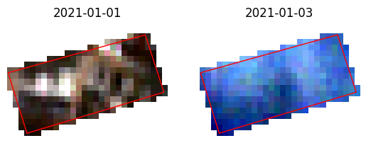
Filtering the meta data
[8]:
ds = tg.create(**arguments, filter={"eo:cloud_cover": {"lt": 95}})
visualize_sat_images(ds, gdf, list(reversed(arguments["bands"])))